**Geography and Climate of Ikaria:**
– Ikaria is a Greek island in the Aegean Sea, covering an area of 255.303 square kilometers with 102 miles of coastline.
– The island is mountainous, with the Aetheras range reaching a height of 1,037 meters.
– Ikaria boasts lush green landscapes, shrubbery-covered ravines, and a tradition of producing strong red wine.
– The island’s wildlife includes goats, martens, European otters, jumping spiders, and green toads.
– Ikaria has a typical Mediterranean climate, contributing to its unique geography and biodiversity.
**History and Antiquity of Ikaria:**
– Inhabited since at least 7000 BC by Neolithic Pelasgians, Greeks from Miletus colonized Ikaria around 750 BC.
– Known as Icaria or Ikaria in antiquity, the island was part of Polycrates’ sea empire in the 6th century BC and the Athenian-dominated Delian League in the 5th century BC.
– Temples dedicated to Artemis, including the Tauropolion, were significant features of Ikaria’s ancient landscape.
– The island’s history is intertwined with myths and legends involving figures like Melanippe, Poseidon, and Theano.
– Local legends and the island’s fearsome reputation in ancient times added to the rich historical tapestry of Ikaria.
**Temple of Artemis at Nas and Medieval Era of Ikaria:**
– Nas was a sacred spot to pre-Hellenic Aegean inhabitants and an important island port in antiquity.
– The temple of Artemis Tauropolos at Nas served as a place for sailors to make sacrifices and offerings.
– Ikaria’s medieval era saw the island as part of the Republic of Genoa’s possessions, with the construction of seven watchtowers along the coastlines for defense.
– Drakano watchtower, a key part of Ikaria’s communication network since ancient times, highlights the island’s strategic importance.
– Unique architectural features and defensive measures, including hidden supplies and communication networks, characterized Ikaria’s medieval landscape.
**Independence, Greek War of Independence, and Second World War in Ikaria:**
– Ikaria broke away from Ottoman rule in 1827 and expelled the Turkish garrison in 1912, gaining independence and becoming part of the Kingdom of Greece.
– The island suffered losses during Italian and German occupation in World War II, with villages like Karavostamo experiencing significant casualties.
– Ikaria’s role in the Greek War of Independence and its struggles for independence underscore the island’s historical significance.
– The exact figures of losses during the Second World War remain unknown, highlighting the challenges faced by Ikarians during this period.
– The island’s resilience and fight for independence are key aspects of Ikaria’s modern history.
**Unique Architecture, Way of Life, and Demographics of Ikaria:**
– Ikarian houses featured bare necessities and hidden belongings, reflecting a unique architectural style.
– Men and women wore similar clothing, and villages were self-sufficient with communal decision-making processes.
– Festivals, team labor, and elder councils played integral roles in maintaining societal integrity on the island.
– Inhabitants of Ikaria, known as Icarians or Icariots, have formed a diaspora in countries like Greece, Australia, the US, Canada, Egypt, and the UK.
– The island’s demographics, with a mainly coastal population and interior mountainous regions, contribute to the diverse and vibrant community of Ikaria.
This article needs additional citations for verification. (March 2021) |
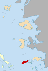
Icaria, also spelled Ikaria (Greek: Ικαρία), is a Greek island in the Aegean Sea, 10 nautical miles (19 km) southwest of Samos.
Icaria
Ικαρία | |
|---|---|
 View of Agios Kirykos, Ikaria's capital | |
| Coordinates: 37°35′N 26°10′E / 37.583°N 26.167°E | |
| Country | Greece |
| Administrative region | North Aegean |
| Regional unit | Ikaria |
| Area | |
| • Municipality | 255.3 km2 (98.6 sq mi) |
| Highest elevation | 1,037 m (3,402 ft) |
| Lowest elevation | 0 m (0 ft) |
| Population (2021) | |
| • Municipality | 8,843 |
| • Density | 35/km2 (90/sq mi) |
| Demonym | Icarian |
| Time zone | UTC+2 (EET) |
| • Summer (DST) | UTC+3 (EEST) |
| Postal code | 833 xx |
| Area code(s) | 22750 |
| Vehicle registration | MO |
Administratively, Icaria forms a separate municipality within the Ikaria regional unit, which is part of the North Aegean region. The principal town of the island and seat of the municipality is Agios Kirykos. The historic capitals of the island include Oenoe and Evdilos.
According to tradition, it derives its name from Icarus, the son of Daedalus in Greek mythology, who was believed to have fallen into the sea nearby.


